Kokthang Glacier Retreat, Sikkim Himalaya, India Doubles Lake Size
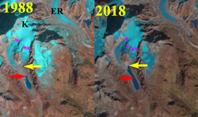
Kokthang Glacier in 1988 and Feb. 2018 Landsat imagery. The red arrow indicates the 1988 terminus and the yellow arrow the upstream end of the lake beyond which the glacier has retreated in 2018. The purple dots indicate the snowline.
Kokthang Glacier drains south from the Kokthang Peak a satellite peak on the south side of the Kanchenjunga Massif, Sikkim in India, the next valley south of East Rathong Glacier. This glacier drains into the Rangit River, which hosts a 60 MW run of river Rangit Hydropower project. Here we examine changes in the glacier from 1988 to 2018. Glaciers draining east from Kanchenjunga have generally experienced substantial retreat and lake expansion (Govindha Raj et al 2013): Lhonak Glacier, Changsang Glacier etc. The exception being Zemu Glacier which has been thinning, but not retreating substantially.
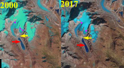
In 1988 the debris covered terminus was in a 800 m long proglacial lake, after the two main tributaries joined. The snowline was at 5500 m. In 2000 the lake has expanded significantly and only the western tributary is actively reaching the lake. The snowline in 2000 is at 5400 m. By 2005 glacier retreat of the stagnant tongue had led to a lake expansion to a length of 1300 m, Google Earth image on left below. The snowline in 2005 is at 5500 m. The eastern tributary no longer descended to the lake. By 2017 the lake had further expanded to a length of 1600 m. The glacier retreat over the 30 year period being greater than the 800 m that represent a doubling of the proglacial lake size. The glacier has now effectively retreated from the lake and only minor expansion will occur with ice cored moraine meltout. The snowline in October 2017 was at 5600 m. The snowline remained high from October to mid-winter as it had in most recent years, with the February 2018 snowline at 5600 m still. This illustrates that ablation albeit, at a slow rate, is occurring from October-mid winter.
The persistent high snowline through much of the year leads to continued thinning and retreat of the lower glacier. The high snowlines have been seen in the Mount Everest area and on Gangotri Glacier. The upper glacier continues to retain snowcover indicating the glacier can survive current climate.
Kokthang Glacier in 2000 and 2017 Landsat imagery. The red arrow indicates the 1988 terminus and the yellow arrow the upstream end of the lake beyond which the glacier has retreated in 2018. The purple dots indicate the snowline. 

Google Earth imagery from 2005 and 2014 of Kokthang Glacier.
Courtesy :-
https://blogs.agu.org/fromaglaciersperspective/2018/06/11/kokthang-glacier-retreat-sikkim-himalaya-india-doubles-lake-size/


No comments:
Post a Comment